.jpg)


https://t.me/STDNX
-
About Division
বিভাগ পরিচিতি
History-Culture
Geographical & Economics
Miscellaneous
-
Divisional Administration
Office of the Divisional Commissioner
Addi Divisional Commissioner/Director, LG
Officers of Field Administrations
About Section
প্রতিবেদনসমূহ
Office Order/ Notification
Projects
-
Local Government
সিটি কর্পোরেশন
কার্যক্রম
-
Government Office
Law and Order Related
-
Chief Judicial Magistrate Court, Sylhet
-
DIG, Bangladesh Police, Sylhet Range
-
Police Commissioner Office, Sylhet Division
-
BGB, Sylhet Division
-
DIG Prisons Office, Sylhet Division
-
Rapid Action Battalion-9 Office
-
Divisional Ansar and VDP office
-
Divisional Fire Service and Civil Defense office
-
Divisional Narcotics Control Office
Education and Culture
Agriculture and Food
-
Divisional Livestock Office, Sylhet
-
Divisional Agricultural Marketing Office
-
Divisional Agriculture Office
-
Divisional Food Office
-
Divisional Fisheries Office
-
Office of the Superintending Engineer, Irrigation Wing, BADC, Sylhet.
-
Joint Director (SM) Office, BADC, Sylhet
-
On-farm Research Division, Bangladesh Agricultural Research Institute
-
Soil Resource Development Institute, Divisional Laboratory
Engineering and Communication
-
Divisional PWD Office
-
National Housing Authority, Sylhet
-
Divisional Post Office
-
Divisional Roads & Highways Office
-
Divisional Electricity Development Board Office
-
Divisional WDB Office
-
Divisional Public Health Engineering Office
-
Divisional Local Government Engineering Office
-
Bangladesh Biman, Sylhet Division
-
Bangladesh Railway, Sylhet Division
-
Divisional BTCL Office
-
BRTA, Sylhet Division Office
-
BRTC, Sylhet Division Office
-
Office of the Superintending Engineer, BREB
Human Resource Development
-
Divisional Cooperative Office
-
Divisional BRDB Office
-
Divisional Statistics Office
-
Bangladesh Karmochary Kallyan Board, Sylhet
-
Sylhet Technical Training Centre
-
Office of the Divisional Social Services, Sylhet
-
Sylhet Women Technical Training Centre
-
Regional Population Training Institute (RPTI), Sylhet
Revenue and financial institutions
Other Offices
-
Jalalabad Gas T&D System Limited, Sylhet
-
জাতীয় ভোক্তা অধিকার সংরক্ষণ অধিদপ্তর
-
বাংলাদেশ বিনিয়োগ উন্নয়ন কর্তৃপক্ষ
-
আবহাওয়া অধিদপ্তর
-
জোনাল সেটেলমেন্ট অফিস
-
বিভাগীয় তথ্য অফিস
-
বন বিভাগ
-
বিভাগীয় পাসপোর্ট ও ভিসা অফিস
-
উপ-ভূমি সংস্কার কমিশনারের কার্যালয়
-
Regional Information Office, Sylhet
-
Office of the District Registrar
-
Chief Judicial Magistrate Court, Sylhet
-
Other Institutions
শিক্ষা প্রতিষ্ঠান
-
E-Service
জাতীয় ই-সেবা
ইউনিয়ন ডিজিটাল সেন্টার
- Gallery
- Job Circular
- Naional Poem
-
About Division
বিভাগ পরিচিতি
History-Culture
Geographical & Economics
Miscellaneous
-
Divisional Administration
Office of the Divisional Commissioner
Addi Divisional Commissioner/Director, LG
Officer & Staffs
Officers of Field Administrations
About Section
প্রতিবেদনসমূহ
Office Order/ Notification
Projects
-
Local Government
সিটি কর্পোরেশন
কার্যক্রম
-
Government Office
Law and Order Related
- Chief Judicial Magistrate Court, Sylhet
- DIG, Bangladesh Police, Sylhet Range
- Police Commissioner Office, Sylhet Division
- BGB, Sylhet Division
- DIG Prisons Office, Sylhet Division
- Rapid Action Battalion-9 Office
- Divisional Ansar and VDP office
- Divisional Fire Service and Civil Defense office
- Divisional Narcotics Control Office
Education and Culture
Agriculture and Food
- Divisional Livestock Office, Sylhet
- Divisional Agricultural Marketing Office
- Divisional Agriculture Office
- Divisional Food Office
- Divisional Fisheries Office
- Office of the Superintending Engineer, Irrigation Wing, BADC, Sylhet.
- Joint Director (SM) Office, BADC, Sylhet
- On-farm Research Division, Bangladesh Agricultural Research Institute
- Soil Resource Development Institute, Divisional Laboratory
Engineering and Communication
- Divisional PWD Office
- National Housing Authority, Sylhet
- Divisional Post Office
- Divisional Roads & Highways Office
- Divisional Electricity Development Board Office
- Divisional WDB Office
- Divisional Public Health Engineering Office
- Divisional Local Government Engineering Office
- Bangladesh Biman, Sylhet Division
- Bangladesh Railway, Sylhet Division
- Divisional BTCL Office
- BRTA, Sylhet Division Office
- BRTC, Sylhet Division Office
- Office of the Superintending Engineer, BREB
Human Resource Development
- Divisional Cooperative Office
- Divisional BRDB Office
- Divisional Statistics Office
- Bangladesh Karmochary Kallyan Board, Sylhet
- Sylhet Technical Training Centre
- Office of the Divisional Social Services, Sylhet
- Sylhet Women Technical Training Centre
- Regional Population Training Institute (RPTI), Sylhet
Revenue and financial institutions
Other Offices
- Jalalabad Gas T&D System Limited, Sylhet
- জাতীয় ভোক্তা অধিকার সংরক্ষণ অধিদপ্তর
- বাংলাদেশ বিনিয়োগ উন্নয়ন কর্তৃপক্ষ
- আবহাওয়া অধিদপ্তর
- জোনাল সেটেলমেন্ট অফিস
- বিভাগীয় তথ্য অফিস
- বন বিভাগ
- বিভাগীয় পাসপোর্ট ও ভিসা অফিস
- উপ-ভূমি সংস্কার কমিশনারের কার্যালয়
- Regional Information Office, Sylhet
- Office of the District Registrar
-
Other Institutions
শিক্ষা প্রতিষ্ঠান
-
E-Service
জাতীয় ই-সেবা
ইউনিয়ন ডিজিটাল সেন্টার
- Gallery
-
Job Circular
Apply Online
Admit Card Download
- Naional Poem
Nomenclature
There are various theories about the origin of the name Sylhet. King 'Guhak' of ancient Gaur state established a haat named after his daughter Shiladevi. Because of this, many people think that the name Silat or Sylhet can be known from 'Shilahat'. Also, according to Hindu mythology, the bones of Goddess Sati fell at 51 places in the subcontinent. Two bones of Sati also fell in Sylhet. Another name for Sati is 'Sri'; Hence the name Srihatta can be derived from 'Sri + Hadd'.
Many people also believe that the name 'Silhat' originates from the command of 'Sil Hot Jah' by Hazrat Shahjalal (RA). In 640 AD, the Chinese Buddhist scholar and traveler Hiuen Tsang mentioned Sylhet as Shi-Li-Cha-T-L. Sylhet is mentioned as 'Silahet' in the book 'Kitabul Hind' by the Muslim traveler Manishi Al Beruni in the 11th century AD. Although it was first mentioned as 'Silhet' in documents during the English period, after Cachar came under British rule in the early 19th century, it was referred to as 'Sylhet' to distinguish it from 'Silchar', the headquarters station of the district. This is how today's Sylhet name was born.
Sylhet District and Sylhet Division
Sylhet district was established on March 17, 1772. Till 1874 this district was under Dhaka division. In the same year, Sylhet was included in the newly created state of Assam. Sylhet district was included in the then East Pakistan through referendum in 1947 during the partition of the country. Sylhet district was then under Chittagong division. Greater Sylhet district was divided into 4 new districts in 1983-84.
At the time of its establishment Sylhet district along with other three districts of Greater Sylhet were under Chittagong division. In 1995, separate Sylhet division started with 4 districts of Greater Sylhet (Sylhet, Sunamganj, Moulvibazar, Habiganj). The first commissioner of the division was Mr. Mohammad Habibur Rahman.
Geographical details
Location
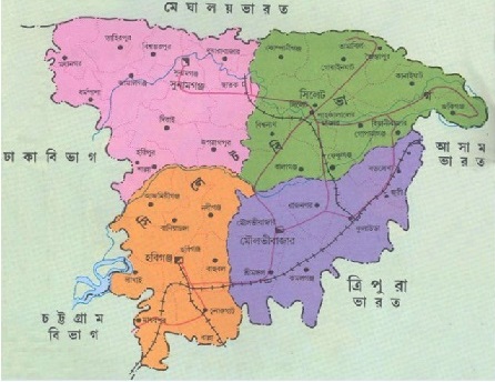
Sylhet division is located between 23°58'W latitude to 25°12'W latitude and 90°56'E to 92°30'E longitude. It is bordered by Meghalaya state of India to the north, Tripura state of India and Brahmanbaria district of Bangladesh to the south, Assam and Tripura states of India to the east, Netrakona and Kishoreganj districts to the west.
Volume
The total area of Sylhet division is 12,558 (twelve thousand five hundred and fifty eight) square kilometers. The area of Sylhet district is 3,452 square kilometers, Sunamganj district is 3,670 square kilometers, Habiganj district is 2,637 square kilometers, Moulvibazar district is 2,799 square kilometers. In terms of area, the largest district of this division is Sunamganj and the smallest district is Habiganj.
Topography
North, east and south side of Sylhet Division is a hilly area of high mountain range. Basically: Sylhet division or ancient Srihatt is the vast area between the hills of Meghalaya, Khasia, Jaintia, Tripura. The interior border is mostly flat desert. There are jungles and small sandy dunes at places.
Many rivers flow within the division. Daughter of Nature Sylhet is a green natural land surrounded by hills, rivers and streams. Tea plantations spread across the hills within the Sylhet division.
Sylhet division at a glance
Administrative
1. Parliamentary Constituencies: Total 19 (Sylhet: 06; Sunamganj: 05; Moulvibazar: 04; Habiganj: 04)
2. Upazila: Total 41 (Sylhet: 13; Sunamganj: 12; Moulvibazar: 07; Habiganj: 09)
3. Border Upazila: Total 19 (Sylhet: 06; Sunamganj: 06; Moulvibazar: 05; Habiganj: 02)
4. Police Stations: Total 44 (Sylhet: 17; Sunamganj: 11; Moulvibazar: 07; Habiganj: 09)
Local Govternment
1. City Corporation : 01 (Sylhet City Corporation)
2. Municipalities: Total 20 (Sylhet: 05; Sunamganj: 04; Moulvibazar: 05; Habiganj: 06)
3. Unions: Total 338 (Sylhet: 105; Sunamganj: 88; Moulvibazar: 67; Habiganj: 78)
Demographics
1. Total Population: 1,10,34,863 (Sylhet: 38,57,037; Sunamganj: 26,95,495; Moulvibazar: 21,23,445; Habiganj: 23,58,886)
2. Village Population : 89,63,639 (81.23%)
3. Urban Population : 20,65,123 (18.77%)
4. Population density: 873 people per square kilometer.
5. Minorities: Manipuri, Khasia, Garo, Patra, Lusai, Hajong, Sawtal, Tripura, Tipra
6. Minority Population: 1,36,594 people (Sylhet: 16,458 people; Sunamganj: 5285 people; Moulvibazar: 73,288 people; Habiganj: 41,536 people)
Educational information
1. Education rate (above 7 years): 71.92% (Sylhet: 76.26%; Sunamganj: 64.77%; Moulvibazar: 75.74%; Habiganj: 69.32%)
2. Educational institutions: Total institutions 6,242
|
S.L No. |
Name of the institution |
Sylhet |
Sunamganj |
Habiganj |
Moulvibazar |
Total |
|
01 |
Government University |
03 |
- |
- |
- |
03 |
|
02 |
Private university |
05 |
- |
- |
- |
05 |
|
03 |
Government Medical College |
01 |
- |
- |
- |
01 |
|
04 |
Private Medical College |
05 |
- |
- |
- |
05 |
|
05 |
Govt Veterinary College |
01 |
- |
- |
- |
01 |
|
06 |
Tibibaya College |
01 |
- |
- |
- |
01 |
|
07 |
Polytechnic Institute |
01 |
- |
- |
01 |
02 |
|
08 |
Vocational Institute |
01 |
01 |
01 |
01 |
04 |
|
09 |
Cadet College |
01 |
- |
- |
- |
01 |
|
10 |
Govt College |
05 |
03 |
03 |
03 |
13 |
|
11 |
private college |
39 |
14 |
19 |
21 |
91 |
|
12 |
Law College |
02 |
- |
- |
- |
02 |
|
13 |
Govt Teachers Training College |
01 |
- |
- |
- |
01 |
|
14 |
Government High School |
06 |
05 |
06 |
03 |
20 |
|
15 |
Private high school |
277 |
149 |
100 |
155 |
681 |
|
16 |
Junior High School |
36 |
22 |
20 |
18 |
96 |
|
17 |
Govt Madrasa |
01 |
- |
- |
- |
01 |
|
18 |
Private Madrasa |
175 |
65 |
53 |
54 |
347 |
|
19 |
Government Primary School |
1,066 |
856 |
732 |
692 |
3,346 |
|
20 |
Private primary school |
295 |
576 |
294 |
280 |
1445 |
|
21 |
Ibtedayi Madrasa |
53 |
50 |
22 |
52 |
177 |
|
Total |
1,974 |
1,741 |
1,250 |
1,280 |
6,242 |
|
Other information
1. Major Rivers:
(a) Surma, Kushiara, Sari, Pian (Sylhet Region)
(b) Kalni, Jadukata, Baulai, Kans (Sunamganj Region)
(c) Manu, Dhalai (Moulvibazar Region)
(d) Khoai, Sutang, Ratna (Habiganj Region).
2. Notable Land Ports: Bholaganj, Tamabil, Sheola, Sutarkandi, Jokiganj and Chatla.
3. Notable Haors:
(a) Hakaluki (Kulaura-Barlekha, Moulvibazar, Golapganj-Fenchuganj, Sylhet)
(b) Hail Haor (Srimangal, Moulvibazar)
(c) Tanguar Haor (Tahirpur-Dharmapasha, Sunamganj)
(d) Shanir Haor (Tahirpur, Sunamganj)
(e) Viewing Haor (South Sunamganj, Sadar, Sunamganj)
(f) Ghungiyazuri, Makar Haor (Habiganj Sadar, Bahubal, Lakhai, Nabiganj and Baniachong, Habiganj).
4. Industrial Plant
|
Fertilizer Factory |
01 (Fenchuganj Fertilizer Factory) |
|
Cement Factories |
02 - Chatak Cement Factory, Lafarge-Surma Cement Factory |
|
Paper Mill |
01, (Chatak Paper Mill) |
|
Textile Mill |
01 |
|
Power Generation Plants |
05 |
|
Bisik Industrial City |
05 |
5. Gas field:
|
Field Name |
Reserve (BCF) |
No. of Wells |
Daily Production (BCF) |
|
A. Productive |
|||
|
1. Habiganj |
953.210 |
10 |
0.2898 |
|
2. Kailashtila |
2254.853 |
04 |
0.0612 |
|
3. Rashidpur |
1059.519 |
07 |
0.1021 |
|
4. Sylhet |
97.059 |
01 |
0.0055 |
|
5. Jalalabad |
717.375 |
04 |
0.1741 |
|
6. Biyanibazar |
156.421 |
02 |
0.0259 |
|
7. Bibiana |
2041 |
|
|
|
8. Fenchuganj |
210 |
|
|
|
9. Moulvibazar |
400 |
|
|
|
A. Production Stopped |
|||
|
1. Chatak (Tengratila) |
241.5 |
|
|
|
Total |
8130.937 |
|
|
Information and Communication Technology
1. Information Portal: Total number: 379 (three hundred and eighty nine).
(a) Divisional Information Portal: 01 (one)
(b) District Information Portal: 04 (four)
(c) Upazila Information Portal: 41 (forty one)
(d) Union Information Portal: 338 (three hundred and thirty eight)
Sylhet department information regarding multimedia classroom
(Last updated February 2016)
|
Serial no |
District Name |
Primary School |
Secondary and Higher Secondary |
||
|
Yes |
No |
Yes |
No |
||
|
01 |
Sylhet |
70 |
975 |
395 |
- |
|
02 |
Sunamganj |
30 |
1409 |
177 |
112 |
|
03 |
Habiganj |
24 |
1006 |
205 |
102 |
|
04 |
Moulvibazar |
21 |
1006 |
247 |
43 |
|
Total= |
145 |
4396 |
1024 |
257 |
|
Tourism
Places to visit in Sylhet Division
1. Sylhet District:
(a) Mazaar of Hazrat Shahjalal (RA) and Hazrat Shahparan (RA), Sylhet.
(b) Jaflong, Sripur, Tamabil, Bholaganj Pathar Quarry, Lakkatura Tea Garden, Bichnakandi, Khasiapunji,
(c) Jaintar Rajbari, Jaintapur, Sylhet.
(d) Sri Chaitanya's birthplace, Golapganj, Sylhet.
(e) Ratargul, Goainghat, Sylhet.
2. Sunamganj
(A) Tekerghat, Sunamganj.
(b) Tanguar Haor, Sunamganj.
(c) Hashan Rajar Bari, Sunamganj.
(d) Hours of viewing
3. Moulvibazar
(A) Madhavkund Falls, Baralekha, Moulvibazar.
(b) Hamham Waterfall, Kamalganj, Moulvibazar.
(c) Bangladesh Tea Research Institute, Srimangal Tea Resort, Moulvibazar.
(d) Lauachhra Reserve Forest, Kamalganj, Moulvibazar.
4. Habiganj
(a) Satchari National Park, Chunarughat, Habiganj.
Liberation war memories
(a) Birshrestha Hamidur Rahman Memorial Tower, Moulvibazar.
(b) Graveyard of General MG Osmani, Sylhet.
(c) Graveyard of Major General MA Rob, Habiganj.
(D) A place called Dolura in Sunamganj district.
(e) Liberation War Memorial adjacent to Teliapara Tea Garden, Madhavpur, Habiganj.
Other Important Places:
(a) Manipuri Lalitkala Academy, Moulvibazar.
(b) Bangladesh Tea Research Centre, Moulvibazar.
(c) Osmani Museum, Sylhet.
(d) Bangladesh Rural Development Training Institute, Khadimnagar, Sylhet.
(e) Agricultural Training Institute, Sylhet.
(f) School of Infantry and Tactics, Sylhet.
(g) MA, A, G Osmani International Airport, Sylhet.


Planning and Implementation: Cabinet Division, A2I, BCC, DoICT and BASIS
Technical Assistance:
![]()
Developed By: